Monday, November 19, 2012

Cedar Breaks (it also smells nice!)

After our long (long) backpack along the West Rim, we were ready for something a little shorter last weekend,  so we decided to take it easy (relatively) and check out Cedar Breaks National Monument.


I'm not exactly sure what the difference is between a National Park and a National Monument - they seem pretty much identical to me.  At first I assumed monument meant there was - well - some sort of monument there.  Like a statue.  Nope.  They are both basically large areas of scenic wilderness with view points, hiking trails, and a small ranger booth to collect your money and answer questions for old codgers in camper vans.


Cedar Breaks could almost be mistaken for Bryce.  It is like Bryce's little cousin.  A huge canon valley full of multi-colored cliffs and spires of sandstone standing like an army of drip sandcastles.  It is just a little smaller (and graciously free of tourists!).


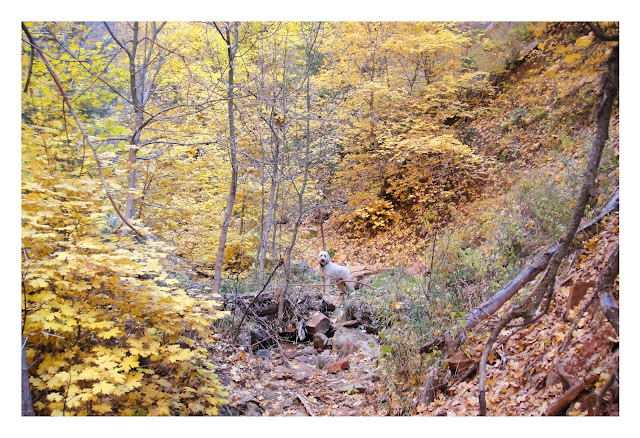
Like Bryce, it is fairly high up in the mountains - in this case right around 10,000 ft - which means while it was still relatively warm in St, George, with leave leaves changing colors and such,  it is downright cold at Cedar Breaks.  Leaves?  Long gone.  Replaced by ice covered twigs and relatively annoyed looking squirrels.

This high up, there is already snow on the ground.  The park (or "Monument"... whatever...)  is already closed for the winter.  The rangers are gone and the facilities are boarded up - but the road is still open.  Once the snow really hits, even the snow plows get scared to be up here, and they just stop plowing - then it's all over until the roads melts free in the spring.


We decided to take advantage of the closure, forgo the silly rule banning dogs, and brought Maggie along.  Yup, we're rebels.

(Let me say again how annoying the anti dog rules are out here...  Don't want our dog in your restaurant?  OK - understandable.  Don't want her in your 1 million acre wilderness?  That's just being silly.)

So the three of us hiked an excellent trail about 4 miles out and back around the rim of the canyon.  On one side, a sheer cliff of several hundred feet opening up to a huge desert valley of sandstone creations.  On the other an ancient pine forest.  Old twisted trees, some as much as 1700 years old, surrounded in snow and fed by a tiny frozen stream.


Having grown up in Newfoundland, snow and frozen streams are fairly common to me, and so I spend most of my time looking towards the canyon.  For Stephanie, having grown up in Hilton Head, snow is still fairly novel, and so she spent most of her time taking pictures of the forest.  As for Maggie, just getting to go with us was enough. She was just happy to finally have some snow again to roll around it.


On the way home we swung by Brian Head, a small ski hill in the area that we intend to spend a lot of time at this winter - me skiing, Stephanie curled up by the fire with a hot chocolate and a good book.  It is the highest peak in the county, and there is a road open to the summit, so we took the new wheels up for a spin.  You could see all the way across Utah and into Nevada and Arizona.


Up Next... Kanarra Creek.

Tuesday, November 6, 2012

Two days on Zion’s West Rim Trail

So…. apparently the desert does get cold in the winter.  Who knew?

St. George is at a relatively low elevation (about 3000 ft) so it stays fairly warm all year.  (Stephanie confirmed that before agreeing to move here.)  Most of the best hiking however is up in the surrounding mountains and canyons between 5000 and 10,000 ft and it gets a quite a bit colder up there.  We had our first real taste of it last weekend on the West Rim trail.

The West Rim Trail.  I like the sounds of that.  Sounds impressive - kinda like we scaled Everest.  I can hear myself now, all withered and old and crotchety sitting in a rocking chair, shaking my cane at the young’ins and their “rock and roll” music, and telling anyone who will listen about how when I was just a wee lad, we were high up on the West Rim when a Nor’wester rolled in and we were trapped for days in the snow with nothing to eat but our shoe laces.  It’s not true of course, but I’ll be pretty darn old, so people will nod and pretend they’re interested.  (They’d better - or I’ll give them a good whacking with my cane!)

Well it wasn’t quite Everest, but it was a feet pounding 14 miles.  Add to that, most of the trail is at about 7000 ft and between the packs, the distance, and the relatively thin oxygen, it was tougher than it sounds.

Getting to the trailhead required hiring an hour long early morning shuttle, so we climbed out of the van to start our hike, just as the sun was coming up – at 7400 ft and a brisk 24 degrees!  We knew we were in for a chilly start when we noticed that a pond we passed was frozen over.  That’s never a good sign when you realize the next time you will step indoors is still a day and a half away.


The trail starts off by crossing a plateau through open fields dotted with huge pines that still showed the scars of a forest fire that went through in 1995.  It warmed up quickly however and we made good time.  So good in fact that we ended up at our intended campsite just after 11 am.  Apparently “somebody” (OK, it was me) had grossly overestimated the time it would take to reach the campsite.  But it was early, the weather was clear and cool, and we hadn’t yet reached the rim of the canyon (and therefore the spectacular views we came for), so we decided to keep moving.


The challenge with backpacking in the desert is:

a) water is in short supply (I know, shocker, right?), and
b) water is obscenely heavy.

These two things don’t go well together.  It is commonly accepted that you need to drink at least 1 gallon of water per person per day – more if you are doing any physical activity.  Add another gallon for cooking and for two people for two days you are looking at about 8 gallons of water - weighing in at a breezy 64 lbs!

So unless you are planning to carry a 100 lb pack or are intent on dying of thirst, you have to plan on finding water as you go.  It is pretty darn important.  The campsite we were leaving was next to a tiny spring.  The next campsite with a spring nearby was another five or six miles down the trail. So overall we covered just over 10 miles before stumbling into our new campsite later that afternoon and learning a very valuable lesson:  eight miles in one day, at elevation, with a heavy pack is more than enough.  Ten miles is too much.


That said, once we got across the plateau and started following the rim of the canyon the scenery was great, and that made it all seem worthwhile.


We set up our tent at the top of a 1000 ft cliff overlooking a beautiful canyon valley, heated up a foil packet of dehydrated chicken risotto for dinner, boiled some water for coffee and watched the sun go down.  Then we ran like hell and climbed into our sleeping bags as the temperature started to plummet...


Morning came with a beautiful sunrise and the distinct realization that it was getting much too chilly to be sleeping in a tent this high up in the mountains.  From now until spring it will be day hikes.


With the tiny spring, getting water was a chore.  It bubbles up out of the ground in a barely perceptible flow, and then almost immediately drops over the edge of the cliff.  We had to use a piece of bark to channel it into a pot, taking five to ten minutes to gather one pot full.


Fortunately, our extra efforts the day before left us with only 4 miles to go – and it was all downhill.  Easy right?  No problem?  We had thought so.  Why then did it feel far, far worse than the day before?

First of all we were already sore from the previous day, and second, the last four miles decended a knee busting 3000 ft to the canyon floor.  Trust me - hiking downhill with a backpack only stinks slightly less than hiking uphill.


Again however, the scenery was incredible.  Trees were in full fall colors and as we approached the final decent to the floor of Zion Canyon the views went from beautiful to stinkin' spectacular.


On the way we passed a turn off for an infamous (and popular) trail known as Angels Landing.   Back in the 30's some unemployed people needed something to do, so the federal government poured money into the National Parks and told them to build stuff.  What did Zion do?  Build possibly the most dangerous hiking trail ever unleashed upon the general public.  Got a bum ankle or a crippling fear of heights?  Don't even think about it.  At one point you cross a ridge only a few feet across with a straight drop of over 1400 ft on either side.  To keep you from immediately falling to your death they have a chain for you to hold onto.  Not clip your harness into, not tie your self onto, just hold...

Considering we were already physically spent, we decided to give this short side trip a miss this time - but I will be back.  Oh yes, I will be back.


Remember the knee busting downhill descent I was talking about?  Here it is.


Almost at the bottom.  See how we are smiling?  Wrong.  Actually we were just gritting our teeth to take our minds off the pain in our feet.


Up next... Miscellaneous stories and photos and stuff!


Monday, November 5, 2012

Spring Creek Canyon

My beautiful wife turned 30 last week.  On the down side, that means I can no longer tell my buddies that I am married to a chick in her 20’s – something I have been milking for a long time.  On the up side however, since she somehow seems to get more amazing every year, I can excitedly look forward to our next year together even more than the year before. (For those of you who know her well, you know just how lucky I am, and are probably wondering how I ever snagged her in the first place.  P.S… I’ll never tell.)

Why am I prattling on about Stephanie you ask?  It is because otherwise she would be conspicuously absent from this post.  For her birthday she flew back to North Carolina to visit her Mom and a few of her closest girly friends.  They all rented a cabin in the mountains where I imagine they probably giggled a lot while drinking wine around a fire pit and eating bon bons in their flannel pajamas – but that is just a guess.  I anticipate she will create a post from that weekend, but in the meantime, I have a post of my own.

Here it is.

So with the wifey out of town it was just me and the dog sitting on the couch watching Breaking Bad and eating block of cheese.  Ah the life of a bachleor!   And if you know me at all, you will know that lasted about 30 minutes before I was horribly bored and pacing the floor looking for something to do. So Maggie and I decided to go hiking. (Actually it was mostly my decision, but I am pretty sure she agreed.)

My first idea was to climb a mountain - something I have been putting off since I got here.  There is one mountain in particular which has been rubbing me the wrong way - peeking at me tauntingly over the sandstone cliffs to the Northeast.  Unfortunately after quickly researching the idea of climbing one, it turns out that most of the mountains in this area are - not surprisingly - somewhat large and what they call “very challenging”.  It is as though they are specifically designed to prevent people like me – with limited physical stamina - from ever climbing them.  With some quick calculations, I quickly deduced that the chances reaching the top of one and getting back down again before dark was… let’s say risky.  (OK fine… it was suicidal.)  So after careful consideration, and remembering that Stephanie specifically made me promise “I won’t kill myself climbing a mountain while you’re gone” (she made me look her in the eyes and repeat that part twice), I decided on a canyon instead.  At least it would be a narrow canyon with big choke stones and the danger of flash floods so that made me happy.


If you look at a list of hikes in the Saint George area, chances are Spring Creek Canyon won’t even appear.  That is just the way it goes out here.  There are simply so many great hikes to do, that some have to be left out just to keep things sensible.  This one is especially overlooked, mostly because it falls just outside the boundaries of Zion National Park.

These are the hikes I look for.  Overlooked means no people.  Outside the park means Maggie can come along.  Perfect.


What I realized right out of the gate is that I hit the timing for this hike perfectly.  The bottom of this deep and narrow slot canyon is lined with scrub oak trees that were at the height of their yellow fall colors.  This mixed with a few orange and red maples, dark green junipers and the red rocks of the canyon walls made for some incredible scenery.


This is a great slot canyon with smooth shear walls reaching over 750 feet high, and in a few places as little as 5 – 6 feet across.  Think of walking down Wall Street if the buildings were only 5 ft apart.  That said, it turns out it was mostly easy hiking, with only a few places where the canyon was choked with boulders that you had to climb over to keep going.


Maggie was a great companion.  She is an experienced hiker but her short dog legs can make scrambling over large boulders difficult.  Fortunately, from previous outings, she has learned that when she approaches an obstacle she can’t surmount on her own, she stops and waits patiently for me to pick her up and push her up and over – an insult she would never normally abide.  Coming down off a ledge is even funnier – she crouches down and inches right up to the edge so I can get an arm under her and gently lift her down.  She runs around excitedly in figure 8’s after each one as if we just conquered Everest.


It still blows me away that scenery like this is right out our back door.  We left the house at about 1 pm, were on the trail before two, knocked out a 7-8 mile hike and were back home again in time for dinner – alive and well.  As promised.

Up next… Two days on Zion’s West Rim Trail.

Monday, October 29, 2012

Dream BIG

I recently read "The Circle Maker". The author Mark Batterson talks about dreaming big and praying hard.  This book rocked my world.  I often underline segments of books that really stand out to me.  Most of this book is underlined.

Today's post was inspired by a conversation I had with a friend. We were sharing struggles that we are currently facing. I hung up the phone - I felt refreshed, hopeful, and felt prompted to write about it. So here goes...

A hundred things spoke directly to me in this book, but the first was: "we should praise God for disappointment because it drives us to our knees." This reminded me that I need to rely on him for everything.  When things are good it's easy to forget this. We start to take care of things on our own. But you know the vicious cycle as well as I do - we get burnt out, stressed out, and are overwhelmed. Then what?  

A game changer for me was the following line: "stop praying and start praising Him for what He was about to do."  Now this is one line taken from a long story, I don't want to imply stop praying, that's not the answer.  The point I want to emphasize is praise God before He answers your prayers. Praise Him for what He is going to do. I love that. I have started doing that. And let me tell you, you will have peace that surpasses all understanding.

"There is nothing God loves more than keeping promises, answering prayers, performing miracles, and fulfilling dreams. That is who He is. That is what He does."  Wow. What an awesome God we serve.

I love The Message version of Ephesians 3:20 -
God can do anything, you know—far more than you could ever imagine or guess or request in your wildest dreams! 

That brings us to a topic I am very passionate about, Dreaming BIG.
I love positive, encouraging quotes. I always have. I have scrapbooks I made in my early teens that are full of famous quotes. Today I surround myself with them. I have scripture hanging on our fridge, quotes written on sticky notes attached to my computer, encouraging notes from friends in my bedroom.  These are reminders for me "If God is for us, who can be against us?" -Romans 8:31

It is really hard for me to narrow down my favorite Circle Maker lines, so here are a few for you ponder.

"Drawing prayer circles isn't about proving yourself to God; it's about giving God an opportunity to prove Himself to you. Just in case you have forgotten - and to ensure that you always remember - God is for you."

"a big dream is a dream that is bigger than you. In other words, it's beyond your human ability to accomplish."

"if you keep trying, you are not failing. The only way you can fail is if you quit trying."

"I have no idea what the future holds, but I know who holds the future."

In the last chapter the author shares his "Life Goal List". "Your life goal list will include goals that are big and small. It will include goals that are short-term and long-term. But I have one piece of advise: Make sure you have a few BHAGs on the list. You need some God-sized goals that qualify as crazy. Here's why: big goals turn us into big people."

My favorite definition of crazy is: intensely enthusiastic; passionately excited.
That is how I want to live my life.  I pray that God will give me dreams this year that are crazier than the year before.

I write all of this from Utah. Well done God. Well done.

~

Obviously I would highly recommend reading the book or at least watching the video online.

Also, Mosaic Church recently did a series on The Circle Maker.  Watch online here.
Under "Series" look for The Circle Maker.  Watch "Shameless Audacity" first :)

What are you dreaming for this year?  I would love to hear your story.  StephanieHuxter@gmail.com

Thursday, October 25, 2012

Hiking with the (other) Huxters - in Bryce Canyon

I’m running out of superlatives.  There are only so many you know.  At some point I am going to have to start repeating myself – there is simply too much scenery here that requires far too many words like “awesome” and “amazing” to accurately describe it.
I was struck with this realization as I sat down to write about Bryce Canyon.  Let it suffice to say that it was so breathtaking, and so overwhelming (so bom-diggity?  Have I used that one yet?), that we are seriously considering naming our second male child Bryce*.
(*Understanding of course that: a) we haven’t quite got child number one out of the way yet, b) by putting this in writing I’ve basically guaranteed us a house full of girls, and c) if and when we get to boy number two we will have probably forgotten that we once thought Bryce was a pretty cool name. )
Still reading?  Good.  In that case I won’t push my luck with too much yappity yap and get right to the photos.  Here are a couple.


Who’s the old fogeys in the photo you ask?  Hey, be nice! That’s my folks!  Good ‘ol Mom and Dad Huxter.  They were in town for the week visiting us from Newfoundland - and since nobody ever really knows where Newfoundland is, we’ve included a map for you below…


Yes that IS a long way away.  Yes that IS really far north.  Yes it IS cold there.  No I did NOT grow up in an igloo.  No we did NOT have a polar bear as a pet!  (Oh stop - now you are just being silly... we had a pet moose of course, like most people.)
My folks pretty much rock.  Apologies to anyone who has lame parents, because mine are the bomb.  We had a hoot travelling around with them, hiking, sight-seeing, playing cards and (though you wouldn’t guess by looking at them) eating pie.  Lot’s of pie.
One little known (and totally awesome) fact about the state of Utah is that the people here apparently love pie.  There’s pie everywhere!   Apple, cherry, rhubarb, strawberry, chocolate, banana cream… you ask for it – they got it*.  (*Except pumpkin.  Much to my father’s dismay, nobody has pumpkin pie.  Nobody.)  Pull into any small town anywhere and you’ve got half a dozen choices for pie, each one advertising that they are the best in town.  One even claimed to be the “Worlds Best Pie”!  Can you believe it? The best in the whole world.  Including the moon.
(Editor’s note, as of press time, the International Pie Tribunal is still withholding their final ruling as to whether or not this small gas station in Rock Pile, Utah does in fact have the “best” pie in the history of the world. )
Ok, enough about pie.  Back to Bryce Canyon.  Here’s another photo.


Pea sixed brain can’t comprehend what you are looking at? Good.  So it’s not just me.  Maybe it was the elevation (the park sits at about 9000 ft) but staring at this view for a long time doesn’t make it easier to grasp, it makes it harder.


The story goes that this enormous canyon filled with thousands and thousands of these “hoodoos” (a.k.a. freaky shaped spires of multicolored sandstone) was formed by some freak accident of water eroding through the softer lower rock layers leaving the harder rock layers perched at the top…but who cares?  They are awesome.  Anyone who comes here, and doesn’t immediately believe in some greater being who wants to show us how awesome he is (especially at building sand castles) has got rocks in their head.


We drove the 18 mile “scenic drive” (understatement of the century) around the rim of the canyon, stopping at a dozen or more view points, each one more baffling than the last.  Then we took a short 3 mile hike down into the canyon through the hoodoos.  They look even crazier up close.


Suffice to say that if any of you get a chance to make it out here we are taking you to Bryce Canyon. It is not an optional part of the itinerary.  Can’t make it until winter?  No problem!  Imagine how neat this will look with snow on it!  We’d probably spend every weekend for the next 6 months backpacking here, but at 9000 ft it is quite chilly in the evenings so we are limited to day hikes. With the snow coming soon even those will get more and more difficult as the weeks go by.   Booooo!
Up next… Miscellaneous photos!  (More interesting than it sounds. Fine, I’ll work on a better title…)

Monday, October 8, 2012

3 Days in the Escalante River Canyon

Who has two arms, likes taking self-portraits, and enjoys hiking deep into the desert and sleeping in a tiny tent?  This chick!


Fortunately (for me) that chick is my adorable wife, and since I have also suffer from a pretty serious backpacking obsession, that makes me a very lucky man!  This weekend we finally got the chance to indulge our backpacking fetish in a very remote part of the world called the Escalante River Canyon.

How remote you ask?  I’m glad you did.  The Escalante River wasn’t even discovered until 1872, making it the last major river discovered in the contiguous United States.  Even today, along it’s entire 90 mile length, only one bridge crosses it.  Simply known as the Highway 12 Bridge, it wasn’t built until 1935 making Boulder, UT one of the last communities in the United States to gain automobile access.

(Before I get to the hike I have to tell you about the drive there.  As a man, I cannot admit to getting excited about fall foliage, but I can say this: The mountain views of the bright yellow aspens on a backdrop of dark pine trees, black lava rocks and red canyon walls were pretty much redonkulous.  This part of the world is just silly beautiful.  It continually amazes you - even when you aren’t looking for it.)


Our hike started in the tiny town of Escalante (population 797) where we left our car behind the cemetery and hiked down a dusty dirt path to the mouth of the canyon.  From there it was a very twisty 15 miles to that one bridge on Highway 12.

How twisty you ask? Good question! The Escalante River has been called “The Crookedest River in the World”.  And while that may be difficult to prove, let’s just all agree that it was pretty darn crookedy.


Why did we pick it from all the awesome hiking choices in the area?  Excellent query!  Partly because it fit all of our “must haves” – a babbling brook, awesome scenery, and a lack of other humans.  And partly because this canyon (amazingly) still lies outside any National Park meaning we could bring Maggie along - who has been pretty miffed about being left at home on previous hikes.

And so off we went.  Three days, two nights, and everything we need to survive strapped to our backs. Not even Maggie gets a free ride.  She carries her own food, bowl, and her wee lil’ boots in her very own doggie backpack.


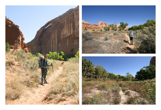
Once again, the scenery was spectacular.  The canyon with it’s crazy high cliffs in crazy colors, twisting back and forth on itself so you can never see more than a few hundred feet ahead or behind.  The bottom of the canyon a garden of grassy fields, sculpted rocks, and huge green and yellow cottonwood trees along an ankle deep stream – perfect for hiking in.


The first day we hiked in about 4 miles, passing possibly the coolest campsite either of us had ever seen.  A huge alcove (a.k.a. shallow cave) a hundred feet high, a hundred feet deep and hundreds of feet wide carved into the sandstone.  Pictographs made by the ancient Anasazi people - who also must have also camped here - decorated the back wall. Unfortunately it had already been claimed by other backpackers (the only ones we saw all weekend).


And so we headed on down canyon, soon finding an idyllic spot of our own in an open field by the river surrounded by massive cliffs on all sides.


Day two we continued down the canyon another 7 miles or so, past more incredible scenery, stumbling across more prehistoric wall art.


The real highlight of the trip was where we stopped to camp the second night on a sharp hairpin turn in the river.   The inside of the bend was a wide soft sandy beach backed by towering green and yellow cottonwood trees.   The outside of the bend was a sheer, smooth, concave, pink colored cliff - curving around us and over our heads to a dizzying height.  From the topo map it looks to be about 500 feet high – or about a 50 story building.


Day three was a final 4 miles as the canyon widened.  More wading in the stream and hiking through grassy meadows between the canyon walls.  As a final highlight, we passed two huge natural arches, one of which had the remains of an ancient Anasazi home built high into the cliff below the arch.  How they got up there, how they built it, and how it is still standing (even the wooden roof is still intact!) makes my face twitch just thinking about it.


... and finally the fantastic drive home.


Up next… Hiking with the Huxters!  (The other Huxters!)